An Intura roadbook
Our roadbooks are so lovingly put together by our team of track finders, so wonderfully detailed with highlighted maps and (almost) step by step directions that we’ll boast about them to anyone who’ll listen! After posting ‘A day on the trail’ and ‘How to choose the right backpack’ we thought it time to share our most precious possession and explain how to read an Intura roadbook. So, lace up your hiking boots and come on a self-guided walking tour around the Chateauneuf du Pape wineries!
1. No nasty surprises along the way, we start by giving you the distance and an estimated walking time (based on no stops, rests or picnics) and the elevation gain.
- WALK - FAMED VINEYARDS
Through the vines, passing the Estates of Vaudieu,
Nalys, Solitude…
2 hrs. 45 mins. 7km. +100m/-100m
2. You’ll never go hungry on one of our self-guided walking holidays, before you’ve even set off for the day, we’ve already forward thought your lunch options! If possible, we will suggest where you can pick up a picnic, ie: local supermarket or bakery as is the case for this walk. On other walks we suggest stopping in a certain village on route if we know of a good restaurant. We also provide an Intura reusable draw string bag – ideal for carrying your picnic goodies and /or souvenir presents and / or bottle of wine along the trail!
- You can pick up picnic items in the supermarket or in the bakeries in Chateauneuf du Pape.
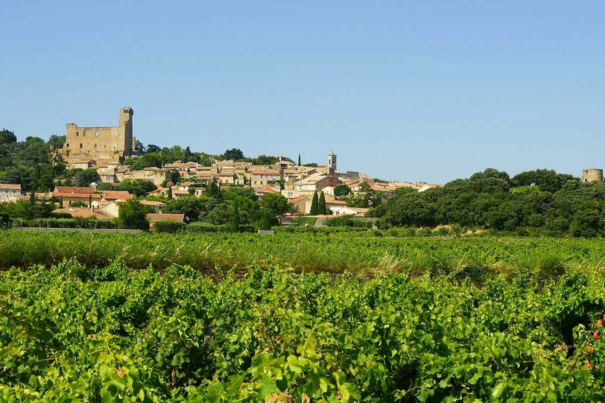
This splendid loop stays within the heart of the Chateauneuf appellation, passing several estates along the way.
You will be on tracks and back country roads that snake through the vineyards. Three of the estates along the way are widely known, and open to the public for wine-tasting.
You are more than welcome to stop in at all three – without reservations – and even pick up a bottle or two for your picnic (make sure you can follow the notes after the wine!!).
Note that Château Nalys, your second Estate stop, has a 5€ charge per person for tastings and given advanced notice they can take you on a complete tour of their domain lasting about an hour.
3. We provide a highlighted map indicating the trail that your self-guided walking tour will take, in this instance, starting from point 0 to point 3. We also provide you with a full-scale map of the region and, if requested, we can send you the GPX files of the walks and rides. We aim to take all of the stress out of orienteering so that you just have to admire the scenery as you walk!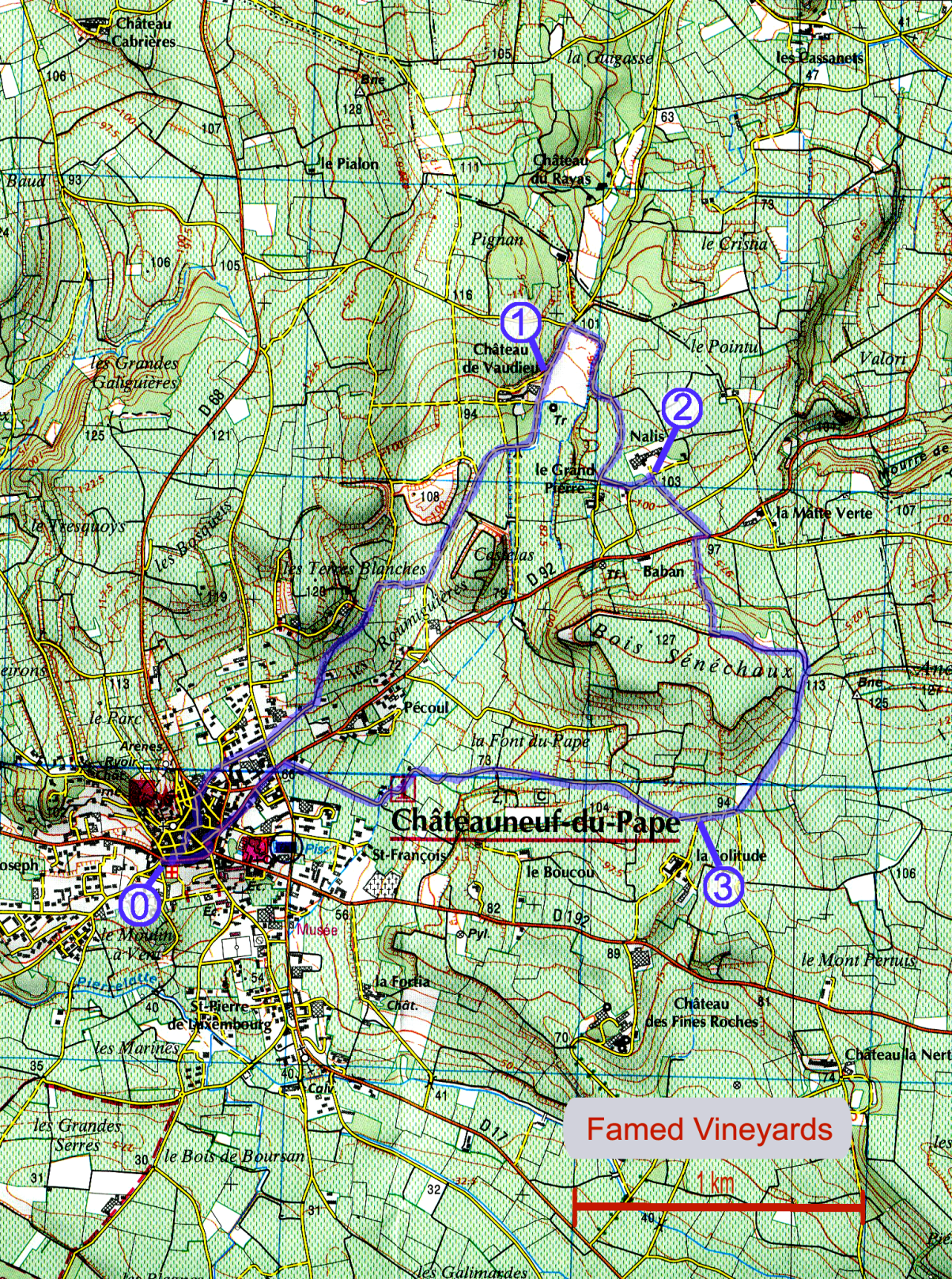
4. The start of your walk is point 0 on your highlighted map and the directions start from there. We provide detailed instructions on the walk including road names and estimated distances.
- POINT 0 - 0h00 CHATEAUNEUF DU PAPE FOUNTAIN
The fountain is located just next to the entrance of “Mere Germaine” Hotel. When facing the hotel “Mere Germaine”, the fountain is on your left hand-side.
From the fountain, climb up the narrow lane into the heart of the old village: on this lane, you will walk by the “Hotel Garbure”, and then the restaurant “Le Pistou”
Turn right on the [Rue Frédéric Mistral]: a tiny cobbled road that exits onto a paved road; turn left onto the paved road. As the road swings to the left (you are facing the dead-end street [Impasse des Montagnards]) you turn to the right, through the tiny archway, towards the road sign "Autres Directions".
Reach the main paved road and continue straight ahead, "Autres Directions".
After only 100m, as the main road swings to the right, you turn off to the left. There are two roads here. Take the one farthest to the right and downhill: [Rue des Cigales].
5. Whenever you pass through a village, town or in this case, winery, we give you a blurb on the place, or a short history lesson, if you will. Time to take a rest, nibble on a snack, read through the info and with a satisfied nod of the head, continue on your Provence walking tour, a little more knowledgeable than before!
- POINT 1 - 0h50 CHATEAU VAUDIEU
The Château Vaudieu, situated in the heart of the appellation of Chateauneuf du Pape, was built in 1767 by the admiral Gérin of Marseille. It was acquired by Gabriel Meffre in 1955. The vineyards have been here in Vaudieu for over 250 years. By the middle of the 19th century, before the phylloxera epidemic, the Estate was only one of four in Chateauneuf du Pape capable of producing more than 20 000 litres of wine. Today the estate is made up of over 180 000 vines, separated into 32 parcels, surrounding the 200-year-old cedar tree. The vineyard is owned and run by the Bréchet family, who also own and run estates in Gigondas, Séguret, and along the French Riviera in La Londe. Here the grapes are sorted well before harvest; bunches of grapes that do not meet standards are taken off, leaving only the best to ripen into August and September. As such, only 25-30 hectolitres of wine are produced per hectare, ensuring only the best quality.
The estate is open for wine-tastings, without the need for reservations. They are closed during the weekend.
04.90.83 70 31
6. The text in green is us, the Track Finders, going ‘Look! Look!’
We’re pointing out the best views, helping you to locate your surroundings and position yourself on the map. We create all of our itineraries. Each one of our self-guided walking holidays is tried and tested so we know when there is a great view to be admired! Our roadbook will be your trusted friend throughout your trip and once you’re home, can sit on the shelf with the other travel books, a souvenir of your walking holiday in France!
- Leaving the Domaine de Nalys (your back to the entrance), walk straight ahead on the dirt track lined by cypress trees on both sides. Notice that rows of each of the 13 varietals are planted here, with signs indicating their use in blending.
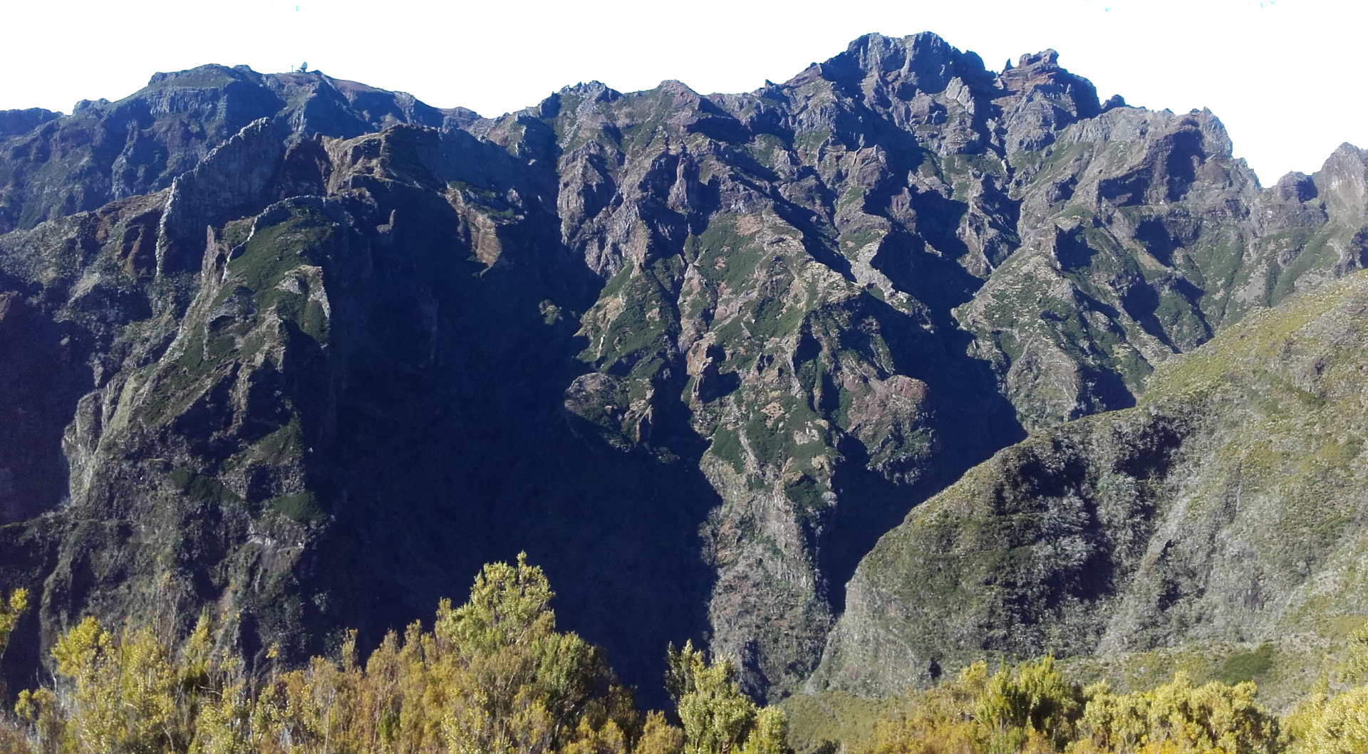
From here you have extensive views to the east (left) of Mont Ventoux and the Dentelles de Montmirail. At 1912m, Mont Ventoux is the highest mountain in Provence, and what may look like snow at its barren peak (if visible) is actually just bare limestone.
Mont Ventoux is full of walking trails but especially known for cycling and the Tour de France: no less than three paved roads lead to the summit!!
The Dentelles de Montmirail are the 3 small chains of jagged limestone teeth that you see to the left of Ventoux.
At their foot is the village of Gigondas, also highly reputed for its deep red wines, which are similar in taste to those of Chateauneuf.
The Mont Ventoux region has its own appellation: Côtes du Ventoux.
At the last cypress tree ignore the road heading left and continue out to the main road. Turn right onto the main road and after only 30m turn left and up a dirt track.
The climb lasts 5 minutes. At the top of the climb you face a plateau of a veritable sea of vines. Here, turn to the left (when facing the vines) onto the grassy track, with the oak trees to your left and vines to your right".